
Source: romanroads.org
Not too long ago, a huge cache of LiDAR data covered more than 72% of England’s land mass was released to the public. Though the agency releasing the data didn’t know exactly what the general population would use the LiDAR data for, it’s clear that the experiment is already paying off—and we’re seeing more creative applications as time goes on.
The data has since been used for flood models, analyzing coastal change, and even scanning for new places to plant wine grapes. (Priorities!)
 Finding Lost Roman Roads
The data has been instrumental in discovering lost Roman roads in the UK. Thanks to the Daily Mail (a site chock full of weird ads), we know that most of the roads were discovered by amateur archaeologists poring over the LiDAR data.
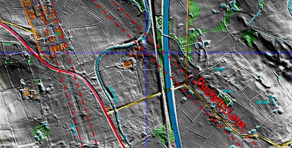
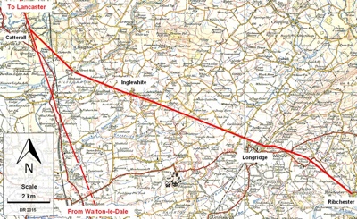
One of those amateur archaeologists, retired road engineer David Ratledge, had spent 45 years searching for these roads in the fields of Lancashire. With LiDAR data in hand, he quickly discovered a 23-mile road between Ribchester (I couldn’t make that name up) and Lancaster. What’s more is that it may be the first Roman road discovered in the UK for 150 years.
For more information on the road, including very detailed descriptions of the road’s path and LiDAR data showing its path, see the exhaustive materials on the discovery over at romanroads.org
 Exploring
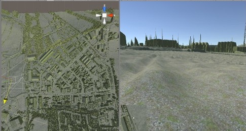
We know that LiDAR data is good for gathering necessary measurement and revealing previously hidden features, but it’s also excellent for pure visualization purposes and exploration. Unfortunately, what we’re presented with when we see a point cloud or a mesh is often very limited compared to the spacious virtual worlds of video games. But, what if we had data for a whole country?
Andrew Sage thought it would be nice to explore.
As he writes in a blog post, “For a very long time, well since my ZX Spectrum days back in the early 1980s, I’ve wanted to be able to explore virtual places on my computer. Nowadays I can, and not just made up places but real places too. My recent virtual adventure took me exploring the area around Carlisle — once I’d first built it of course using some Open Data, the Unity 3D engine, some coding skills and the tech I’ve still not got bored of — my Oculus Rift VR headset.”
Unfortunately, as he found, the LiDAR data for his home in Scotland was not yet available—much like LiDAR data collected for a number of other countries. So, this raises the question—Why not? Why isn’t all the LiDAR data open?


