The Geospatial Technology Competency Model (GTCM), which has recently been updated, identifies what successful geospatial professionals should know, and what they should be able to do. It was originally developed in 2010 for the Department of Labor by panel of experts convened under the auspices of the Geospatial Technology Center of Excellence, sponsored by the National Science Foundation.
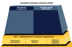
The model is based on a pyramid. At the lower levels, Tiers 1-3, it articulates the common personal and professional skills needed to be a generally successful employee. Tier 4 describes the fundamental body of technical knowledge that all geospatial professionals share. Specialization with the geospatial profession is represented at higher levels of the pyramid. (A complete description of the model is available at http://www.careeronestop.org/competencymodel/competency-models/geospatial-technology.aspx)
The GTCM does not prescribe curricula and is not a set of requirements for academic accreditation. Instead, the model clearly establishes outcomes by which the employability of a graduate will be measured. These outcomes can be interpreted by educational institutions as goals or guidelines for program development. Institutions that follow this guidance will be preparing their graduates to be successful in the current job market and to adapt to future changes in the rapidly evolving world of geospatial data, technology, and applications. Training an individual in specific skills is important, but that training alone does not prepare the graduate for a 30 to 40-year long career in a rapidly changing, economically fluctuating job market.
As described in Tier 4, individuals entering the geospatial profession are expected to be competent in areas including, but not limited to, earth geometry, georeferencing systems, surveying methods, terrain modeling, photogrammetry, multispectral and hyperspectral imagery, spatial and topological data relationships and analysis, and metadata. In addition to the technical competencies, there is an expectation that the individual understand legal and ethical issues of practice, including property rights (real property, as well as data and information), privacy, and rules of conduct.
Tier 5 apportions the geospatial profession into industry sectors with clusters of more specialized competencies. After achieving mastery of the broad competencies described in Tier 4, an individual will often make a career decision to become expert in one of these sectors: 1) data acquisition, 2) data analysis and modeling, or 3) software and application development. Professional certification and licensure may be required for some occupations at the Tier 5 level, and a demonstration of Tier 4 knowledge and experience is often a requirement for this type of credential.
The number of traditional jobs in land development and construction are rapidly decreasing, bright students are not attracted to this diminishing job market, and educational institutions are justified in dropping courses and programs due to lack of enrollment. On the other hand, the geospatial profession is growing explosively, its boundaries expanding and intersecting with many other industries and applications. Opportunities for exciting jobs are emerging in technology companies such as Google, Microsoft, and Nokia, in the green energy sector, and in business intelligence.
There is legitimate concern that individuals filling those jobs may be using many geospatial technologies (GPS, GIS, remote sensing) as a black box, without proper preparation in the principles contained within. Traditional practitioners should be concerned about the increasing substitution of the black box for a less-thoughtful form of calculation and analysis. No one should be opposed to increased efficiency, but all should be concerned about the consequence of using automated tools in the absence of educated judgment.
The only answer to this concern is education and a lot of it, delivered in a format that compels students and ignites in them the passion for pursuit. They must see, and educational institutions must present, the geospatial profession as an exciting, evolving, challenging, and potentially lucrative career opportunity. The GTCM attempts to describe, structure, and map this opportunity in a comprehensive way and very practical way. The GTCM can be used by individuals to plot the long-term course of their careers, it can be used by employers to guide hiring and adapt organizational structure, and finally, it can be used by educational institutions to make strategic program decisions. The time spent to become familiar with this important publication by the Department of Labor will be rewarded. It can be used in mentoring others, and encouraging educational institutions to adopt this model in existing and new curriculum development.