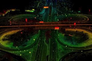
Screenshot of video from Spicer Group
So, you want to capture every dimension?
Mobile Mapping is coming of age. In recent weeks, you may have read Brent Gelhar’s article chronicling the last 10 years of mobile LiDAR. What’s more, Fugro Roadware has reminded us on social media that vehicle-based mobile asset collection systems have in fact been around since 1983. Even more timely was the recent Intergeo exhibition, where there was a notable reduction in the overall marketing impact of mobile mapping systems in general compared to previous years.
Before going further, I should disclose that I joined Optech Incorporated (now Teledyne Optech) in late 2007, very shortly after the fanfare that came with their launch of the Lynx Mobile Mapper. I subsequently sold the product into Europe before moving on to a global sales role at Fugro Roadware for their ARAN pavement data collection system.
It’s clear that we as an industry have realized the efficiency gains that can be brought from capturing data on the move, and a couple of trends are now becoming apparent:
The launch of a manufacturer’s new mobile mapping system does not necessarily come with fanfare
This is not a function of cash-strapped marketing—there is now more of an understanding of what a mobile mapping system consists of. The technology’s acceptance among our customers is not at the same stage as static scanning, but the outputs are now accepted. This is true to the extent that many firms that invested in mobile mapping systems early are now re-investing in new systems after the first have depreciated. It is also a far more common sight now to see operators with multiple mobile mapping vehicles.
Bespoke, flexible and user-defined systems are becoming common
With this increased understanding of what makes up a mobile mapping system, we are seeing system implementations coming in many flavors. At Intergeo, we saw the nicely packaged new Streetmapper IV use the innovative and smaller VUX sensor by RIEGL that many of us connected to their UAV platform. We also saw high-grade mobile mapping in an increased range of (smaller) ground-based platforms.
Furthermore, Brent describes how systems offered by companies such as Siteco are enabling an increased range of user-configurable setups, with system infrastructures that enable the use of a number of types of terrestrial scanners that might otherwise be underutilized.
Click here for part two of William’s two-part series on trends in mobile LiDAR.


