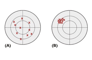
There is a difference between precision and accuracy.
- The more precise the overall measurement, the tighter the clustering of individual measurements. You don’t need a truth set to evaluate precision–as long as the measurement results are highly repeatable, they are precise.
- You do need a truth set for evaluating how accurate a measurement is. The higher the certainty that a measurement is the truth, the more accurate it is.
Suppose the truth in the figure is the center of each target. In that case, the measurements in C are both accurate and precise.
However, when it comes to accuracy there are other important details too. Local accuracy and network accuracy are not the same.
- Local accuracy (or relative accuracy) represents the uncertainty in the positions relative to the other adjacent points to which they are directly connected.
- Network accuracy (or absolute accuracy) requires that a position’s accuracy be specified with respect to an appropriate truth set such as a national geodetic datum. For example, differentially corrected GPS survey procedures which are tied to CORS stations, which represent the National Spatial Reference System of the United States, provide information from which network accuracy can be derived.
It is typical for uncertainty in horizontal accuracies to be expressed in a number that is radial. The uncertainties in vertical accuracies are given similarly but they are linear, not radial. In both cases the limits are always plus or minus (±). In other words, the reporting standard in the horizontal component is the radius of a circle of uncertainty, such that the true location of the point falls within that circle at some level of reliability, i.e. 95-percent of the time. Also, the reporting standard in the vertical component is a linear uncertainty value, such that the true location of the point falls within of that linear uncertainty to some degree of reliability. In GPS positioning it is reasonable to expect that the vertical accuracy will be about 1/3 that of horizontal accuracy. In other words, if the absolute horizontal accuracy of a GPS position is ±1m then the estimate of the absolute vertical accuracy of the same GPS position would be ~±3m.
The Federal Geodetic Control Committee (FGCC) wrote accuracy standards for GPS relative positioning techniques. These were preceded by older standards of first, second, and third order that then became subsumed under the group C in the newer scheme. In those new standards the FGCC’s B, A, and AA categories were respectively 10, 100, and 1000 times more accurate than first-order. With the advent of GPS the attainment of these accuracies did not require corresponding 10-, 100-, and 1000-fold increases in equipment, training, personnel, or effort. They were now well within the reach of private GPS surveyors both economically and technically. These accuracy standards are now superseded. In 1998 the Federal Geodetic Control Subcommittee under the Federal Geographic Data committee published the Geospatial Positioning Accuracy Standards Part 2: Standards for Geodetic Networks. They are here.


