The need to know the location of underground utilities, particularly active pipelines is well known. The dire consequences of not knowing their location is sometimes not as obvious as it should be.
However, last June 30th during the rollout of an underground utility location standard known as Publically Available Specification 128 (PAS-128) in the UK, a rather stark reminder was given. It was presented by Andy Rhoades, Head of Service Protection, LHR Airports – Heathrow. The following image was provided in the accompanying video, which can be viewed here.
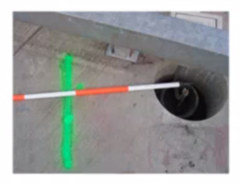
Note the small hole at the end of the red and white range pole shown in the photo at the lower left of the slide. That is a newly installed base foundation for a lightning rod at Heathrow Airport.
The green painted line is the center of a 20-inch fuel main pipeline under pressure. Here is what would have happened if the rod had been installed and struck by lightning:
“This would have punched straight through the pressurized pipe and resulted in a jet of fuel up to 150m high at 10,000 – 20,000 ltrs/min. Fuel would have flowed for 10 minutes, 2 minutes for alarm to be raised, 4 minutes for us [Airport Fire Service] to get there, 4 ½ minutes for fuel to stop flowing after hitting the Fuel Stop Buttons and informing HhOpCo Control.” The flood of fuel produced by the event would have covered a 1 km square at 1 cm deep and created a 500m exclusion zone from the point of the incident.”
One can only imagine the explosive potential. Luckily this was a near miss and not an actual incident.
The PAS-128, established by the Institute of Civil Engineers (ICE), has some similarities with the ASCE Standard Guidelines for the Collection and Depiction of Existing Subsurface Utility Data used in the US. Both standards use quality levels A, B, C and D that help to define the reliability of subsurface locations.
Quality level A is the highest and Quality Level D the lowest in both. Quality Level D is location derived from researching records. Quality Level C location is developed from surface evidence. The PAS-128 Quality Level B makes mention of electromagnetic location and ground penetrating radar. It also contains sub-classifications with horizontal precision objectives from +/- 0.2 meters for B1 and B2 to +/- 0.5 meters for B3 and B4. Quality Level A involves uncovering the utility with a precision goal of +/- 0.025 meters both horizontally and vertically.
The PAS 128 is not (at this point) a government regulation. It is a voluntary code that a practitioner is required to follow if the client wishes to commission a PAS 128 compliant survey. There is no obligation for clients to commission PAS 128 compliant surveys. Nevertheless, it does indicate a serious two-year effort with much industry buy-in to solve an infrastructure problem in the UK.
The standard can be purchased here.
The development these standards demonstrate the importance of underground utility location. However, the focus is on closed ditch detection. It may provide a better outcome if the location of underground utilities was mandated when the ditch is open.