

I provide elevations in terms of Mean Sea Level (MSL) is there something wrong with that?
Yes, there is.
It is hard to overstate the amount of effort devoted to the differential spirit level work that carried vertical control across the United States. The first transcontinental precision leveling surveys done by the Coast and Geodetic Survey were followed by thousands of miles of spirit leveling work of varying precision. The work eventually necessitated more than one adjustment of the vertical network in the early 20th century. While that work was being performed, it was revealed that reliance on Mean Sea Level as a reference frame was troublesome.
For one thing, it became apparent that the surface defined by tidal observations had a tendency to slope upwards to the north along both the Pacific and Atlantic Coasts. It turned out that the Atlantic Ocean north of the Gulf Stream’s strong current is around 1m lower than it is further south. And the more dense water of the Atlantic is generally about 40 cm lower than the Pacific. Despite all this, an attempt was made to constrain the national Sea Level Datum of 1929 to the definition of Mean Sea Level at 26 tide stations, 21 in the United States and 5 in Canada.
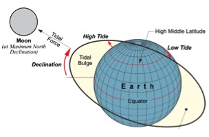
Since sea level was the intended foundation, it might make sense to say a few words about the forces that shape it. Both the Sun and the Moon exert tidal forces on the Earth, but the Moon’s force is greater. The Moon makes a complete elliptical orbit around the Earth every 27.3 days. At any particular moment its gravitational pull is greatest on the portion of the Earth that happens to be closest to the Moon and that produces a bulge in the waters on the Earth.
On the side opposite the bulge centrifugal force exceeds the Earth’s gravitational force and water in this area is forced to create another bulge. The two bulges are not stationary. They move, not only because the Moon is moving slowly relative to the Earth but also because the Earth is rotating in relation to the Moon. Therefore, a coastal area in the high middle latitudes may find itself with a high tide early in the day when it is close to the Moon, a low tide in the middle of the day when it is has rotated away from it. This sort of tide with one high water and one low water in a lunar day is known as a diurnal tide.
Also, the Moon’s declination varies from its minimum of 0º at the equator to its maximum over a 27.2-day period, and that maximum declination oscillates too. It goes from +/-18.5º up to +/-28.5º over the course of an 18.6-year cycle. Therefore, if you want to be certain that you have recorded the full range of tidal variation at a place you must observe and record the tides at that location for 19 years. This period is sometimes called the Metonic cycle. This is the foundation of defining Mean Sea Level at a place.
Mean Sea level is the arithmetic mean of hourly heights of the sea at a primary-control tide station over a period of 19 years. The mean in Mean Sea Level refers to the average of these observations over time at one place. It is does not refer to an average calculation made from measurements at several different places. The Sea Level Datum of 1929 untenable because it was fixed to MSL to 26 different and distinct Local Mean Sea Levels not to mention the variations caused in it by differences in water’s temperature, salinity, currents, density, wind and other physical forces that change the sea surface’s topography.
When it became obvious that the Sea Level Datum of 1929, SLD29 did not coincide with MSL its name was changed. It became the National Geodetic Vertical Datum of 1929, NGVD 29. Later, when the NGS thought it time to consider a new adjustment it took a different approach. Instead of fixing to many tidal stations the new adjustment was constrained to only one not 26. That station is Father Point/Rimouski, a station on the southern bank at the mouth of the St. Lawrence River. The huge network that we currently use is not subject to the variations in sea surface topography, the Metonic cycle, etc. because it is actually not a sea level datum at all. It is known as NAVD88.


