
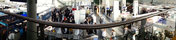
SPAR Europe and the European LiDAR Mapping Forum haven’t technically started yet, but we have already had a very busy pre-conference day. While some were setting up the exhibit floor yesterday (picture below), others spent the afternoon attending presentations on the latest and greatest in hardware and software solutions. That is, there’s a ton to report on already, but here are the essentials.
Here’s what I’ve learned already during those presentations and my time walking the bustling exhibit floor.
The UAV Market is Booming
While we in America are hemming and hawing about FAA regulations, Europe has already jumped in with both feet. Not only have I seen a bunch of European companies here with their own UAVs or UAV-specific solutions, but I’ve also seen a few European companies that offer nothing but product solutions created specifically for UAVs.
Tristan Allouis, PhD, with R&D for YellowScan, was on hand to talk about YellowScan’s sensor. This sensor, he said, was developed in response to both the need for LiDAR data and the booming UAV market. The idea is refreshingly simple: develop “a very small sensor that can provide good quality data from a UAV.”
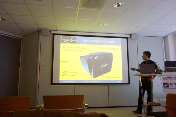
They did this by combining an attitude and heading reference system, a dual-frequency GPS receiver, a multi-echo laser scanner, a battery, AND an on-board computer into a single package under 2.2kg. This makes it such that you can essentially just bolt this little box on to a UAV and then go. The requirements of the UAV don’t seem much more specific than that, and to hear Allouis describe it, it’s definitely a turnkey solution: “It is attached physically to the UAV, but there is no link, no power cable, and everything is in the LiDAR.”
Routescene was also on hand showing a similar turnkey solution, the LidarPod, which that they launched at Intergeo earlier this year. The system is also a self-contained LiDAR rig, including a Velodyne HDL-32, GPS / INS, radio telemetry, data storage, and power management all within a container that weighs in at less than 2.5kg. But this isn’t even what I found most interesting about it.
A Different Way to Define “Solution”
Yes, the system is small, it’s turnkey, it’s easy to use, and it’s light. But it’s also a solution in a way that makes me think what this industry considers to be a solution might just be changing.
As the Routescene presenter told the audience, the design process for the LidarPod involved more than a few dilemmas. “You have your curve of accuracy vs. weight, and accuracy vs. cost, and you have to sit somewhere in between. If you go really, really, accurate, with some high-grade low-drift INS, you’re talking 15kg–and that’s unrealistic. On the other end of the scale is an iPhone-type GPS receiver. So we did a lot of research to work out where we actually sit there and find the right receiver.”
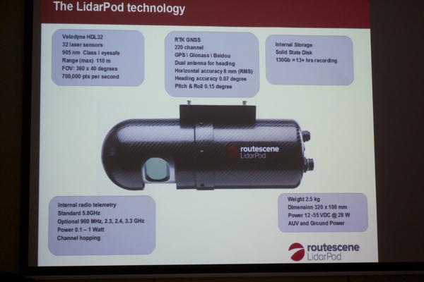
They wanted to make sure that the system was properly built for survey & mapping, that it was precise enough but no more precise than that, as extra precision would make the system too heavy. I had always considered a solution to be an end-to-end hardware/software combination, but this another way to think about it–a finely tuned instrument that meets all your requirements and nothing more.
It’s not sexy to think of a solution as being technologically “adequate,” but saving money isn’t really the sexiest thing either and we certainly do love that.
The Hardware and Software are Maturing at an Astounding Rate
Needless to say, that way of thinking about “solutions” wouldn’t have seemed plausible back when flying a LiDAR required an entire plane full of batteries. Before we could talk about building something that is strategically spec’ed out, we needed to make the technology work.
This is related to my biggest takeaway from the product presentations–the state of hardware and software is becoming impressively sophisticated.
Safe Software, for instance, presented on their FME software, which moves data between over 300 formats across point cloud, GIS, CAD so you can use it in your favorite application. The text on their brochure describing the compatible formats is printed in five columns of tiny type, and it takes up a whole page.
On top of that, Kubit impressed the audience with the speed of Pointsense, and IXBlue presented their new(ish) Atlans-C position and orientation solution for LiDAR sensors. I saw a lot of people furiously taking notes during these presentations.
That’s all for now, but there’s plenty more coming, so stay tuned tomorrow for more from SPAR Europe and ELMF.


