

In my next four blogs I would like to address four questions about reference frames that arise frequently. Here is the first.
My client needs delivery in North American Datum 1927 (NAD27). What is the best way to do that?
The most typical answer to this question is use NADCON. However, there is a good reason to exercise some caution when doing so.
Most control these days is done with GPS/GNSS observations. It is necessary to process these observations to produce control coordinates, and this processing is often assigned to the free online utility from the National Geodetic Surveys, which is known as the Online Positioning User Service (OPUS). The utility allows the user to submit RINEX files through an NGS Web page where they are processed automatically with NGS computers and software utilizing data from three CORS that may be user selected. (The acronym CORS stands for the network of Continuously Operating Reference Stations. GPS signals collected and archived at these sites of known position provides base data that serves as the foundation for positioning in the United States and its territories. The results are delivered in North American Datum 1983 (2011) [NAD83 (2011)] or International GNSS Service 2008 (IGS08). The NAD83 (2011) values are the most commonly used. Using this system makes deriving control coordinates easy, convenient, and free.
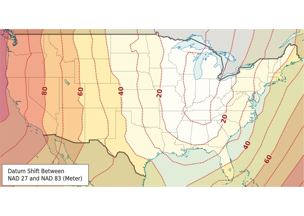
When it is necessary to produce control coordinates in NAD27, the transformation software typically used is the North American Datum Conversion utility (NADCON). This software is the Federal standard for performing datum transformations between NAD27 and NAD83 (1986) and also between NAD83 (1986) and NAD83 (HARN). Nevertheless, it is worthwhile to note NGS’s warning:
“The accuracy of the transformations should be viewed with some caution. At the 67 percent confidence level, this method introduces approximately 0.15 meter uncertainty within the conterminous United States, 0.50 meter uncertainty within Alaska, 0.20 meter uncertainty within Hawaii, and 0.05 meter uncertainty within Puerto Rico and the Virgin Islands. In areas of sparse geodetic data coverage, NADCON may yield less accurate results, but seldom in excess of 1.0 meter. . . . Transformations between NAD 83(86) and States/Regions with High Accuracy Reference Networks (HARNs) introduce approximately 0.05 meter uncertainty. . . . For example, NAD 27 to HARN requires a transformation from NAD27 to NAD 83(86) first and so the uncertainty would be 0.15 meter + 0.05 meter = 0.20 meter.”
In other words, transformation from your GPS/GNSS OPUS processed NAD83(2011) values to NAD27 values will have an absolute 1 sigma reliability of around ±0.7 ft. and a 2 sigma reliability of around ±1.5 ft. or so. These values are within the usual parameters of post-processed work from so-called mapping grade GPS/GNSS receivers. This raises the question of whether or not so-called survey grade receivers are pertinent to doing work that must be reported in NAD27.
There is another element to note, as NGS writes:
“NADCON cannot improve the accuracy of data. Stations that are originally third-order will not become first-order stations. NADCON is merely a tool for transforming coordinate values between datums. Remember, this program is based exclusively upon data within the official National Spatial Reference System (NSRS). Data originating from stations not part of this official reference may not be compatible.”


