
A lot of us missed this story when it was published back in February. (In my defense, I hadn’t even started with SPAR yet…). Even if you caught it the first time around, it’s worth revisiting in depth: A LiDAR chip has been developed that could enable LiDAR systems to work faster, weigh less, and cost less. This means better LiDAR for applications that require extremely high speed capture, like self-driving vehicles. It also means we may be able to put more powerful LiDAR in places where it is usually too heavy, like on small UAVs.
The MIT Technology Review explains the chip to the uninitiated. “LIDAR systems fire lasers and detect returning photons, using the timing of those return trips to measure distance and thus make 3D images.” This new LiDAR chip, which detects the returning photons, has “the largest-ever array of pixels that detect just one photon apiece—more than 16,384 pixels in all. The array of pixels, when paired with optical lenses, allows imaging of wider areas.”
This array configuration, with a huge number of sensors capturing information from each laser pulse, captures scenes very quickly. Even four years ago, as the Tech Review explains, the technology was pretty impressive: “A single pass by a business jet at 10,000 feet over Port-au-Prince was able to capture instantaneous snapshots of 600-meter squares of the city at a resolution of 30 centimeters, displaying the precise height of rubble strewn in city streets.”
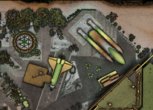
Image/Caption Source: MIT Technology Review
The Space Shuttle Atlantis parked at the Kennedy Space Center in Florida appears in a 200-meter-by-200-meter image taken at night from 13,600 feet in just 18 seconds by a previous version of the advanced LIDAR technology.
It’s certainly not survey quality–30 centimeters is hardly super precise–but it’s a good start. And according to Dale Fried of Lincoln Laboratory, who developed the technology, the latest version is already 40 times better.
The article closes out with a big promise from Fried. Getting rid of some moving parts and developing bigger arrays, he says, will “revolutionize the price point for 3D imagery, by a factor of 10 or more, thereby opening up new applications.”
Flash LiDAR Details and Benefits
The Tech Review’s article, though very exciting, is missing some important details. To learn more about the technology at its center, I contacted Lewis Graham, President and Chief Technical Officer of GeoCue as well as chair of the LAS Working Group, the LiDAR format standards committee at the American Society for Photogrammetry and Remote Sensing.
As he explained, the Port-Au-Prince project mentioned in the article was an early proof of concept for a technology called “Flash” or Focal Plane Array (FPA) LiDAR. The results of that project weren’t nearly as good as conventional scanning systems, but it was still very early in the game for flash LiDAR.
Graham also explained that there are actually two different types of FPA/flash LiDAR currently being pursued. Both use solid state arrays of pixels that detect one photon each.
The first type of FPA/flash LiDAR uses solid state arrays that Graham says “work much like today’s avalanche photo diodes in ‘linear’ mode.” That may or may not mean something to you, but the benefits of the tech definitely will, as he explained that this technology “significantly reduces the mass and power requirements of airborne LiDAR as well as promising to improve geometric accuracy.” He added that, “in addition, of course, data rates will go up since today’s LiDAR systems essentially fire and process a single pulse at a time whereas the focal plane array systems will enable parallel processing.”
When I asked him if the technology could mean LiDAR rigs that are light enough to mount on a small UAV (like a quadcopter) but still powerful enough to be useful, he said, “Yes, this is an excellent and exciting opportunity area for FPA LiDARs. The low altitudes of these sensor deployments means that FPA LiDARs used for this purpose could have smaller collectors (lenses), lowering the overall mass of the system.”
The second type of FPA/flash LiDAR seems ideal for non-UAV airborne applications. This type is usually called Geiger Mode LiDAR, and “biases the array such that it has a very high probability (usually around 30%) of triggering into avalanche mode.” Again, the technology may be complex, but the benefits are simple: “This mode of operation will allow very high flying heights (but at the cost of some accuracy) as well as detecting returns when very few photons are reflected by the impinged project. Thus this mode could be quite useful for “seeing” through very dense foliage to detect hidden objects, electric distribution lines in heavily vegetated environments and so forth.”
Hardware Flaws
The technology seems like it solves a number of the perennial problems that come up when trying to implement LiDAR: it’s fast enough to capture 3D video when you put it in a car, it’s light and powerful enough to be useful when mounted on a quadcopter, and it can “see” through dense foliage. Are there any downsides?
There are a number, says Graham. Though less power is required in the sensors for the linear mode flash LiDAR, the laser itself requires more power “than in a conventional airborne scanning system, since thousands of detector sites must receive energy rather than the single collector site of a scanning system.”
Another problem is that flash systems in Geiger mode are very sensitive to noise like ambient light. So much so that “some experimental Geiger mode systems must be flown at night.” Furthermore, in Geiger mode, a flash LiDAR system is incapable of detecting the intensity of the return. “This means that the Geiger mode detectors provide range information only, not scene illumination.”
In other words, the technology isn’t perfect yet. But it’s certainly worth keeping an eye on.
When/Where Can I Get It?
As of February of this year, according to the Tech Review, “the technology has been licensed to two companies, Princeton Lightwave of Cranbury, New Jersey, and Spectrolab, a unit of Boeing in Sylmar, California, which are engineering them into products.”


