One of the goals stated in FARO Jay Freeland’s keynote address this year was the democratization of 3D laser scanning technology, and the presentations on the second day of the conference drove home the value of that goal. Alongside a track of AEC sessions (an industry that typically has enough money to afford this kind of technology), there were a number of sessions on forensic laser scanning for accident reconstruction, as well scanning and 3D printing for heritage preservation. The forensics and heritage preservation users are clearly important to FARO, and the company seems aware that they can be hard up for the funding needed to buy technology that would do them a world of good.
As proof of how much good the technology can do, take the keynote by Dr. Lori Collins from the Alliance for Integrated Spatial Technologies (AIST) at the University of Southern Florida. Collins spoke on the use of 3D scanning technology to combat what she calls the “diminishing visibility” of our cultural heritage. This might refer, of course, to the deterioration of buildings or monuments exposed to weather and regular human use, but Collins told the room that it applied to archaeological finds as well. “As soon as we dig something up from the ground, we are exposing them to air quality that is deteriorating them.”
She then showed a picture of an ancient carved-stone artifact from 1972 next to a picture of the same artifact taken recently. “You can see a lot of that surface detail has been lost. What that means is that we’re losing our archaeological heritage.” Scan it, however, like Collins and her colleagues have done, and that detail can be preserved indefinitely. Here, 3D scanning might truly be the only way to preserve such archaeological finds for posterity.
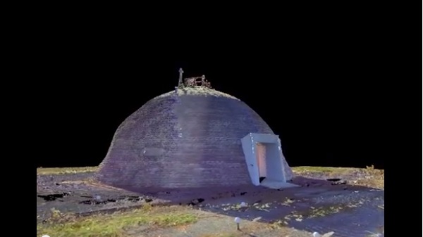
Another salient point Collins made is that we aren’t losing only ancient artifacts, but “we are losing our recent past as well.” Even if you don’t really care about a bunch of old stuff we dug out of the ground, you’ll probably care about this: at Cape Canaveral, there is a building complex that is deteriorating, a complex associated with John Glenn’s orbit of Earth, the Mercury mission, missile launch complexes built during the Cold War, and more. Collins’ presentation explained how AIST, in cooperation with the Air Force, are scanning the complex to preserve it.
And they’re doing it so fast that the presentation effectively doubled as a way of making the business case for the use of 3D scanning in all industries. “Archaeologists spend their whole lifetimes on sites like this,” she said, “and we can go in literally in a week and accomplish what we need to, gathering field data, and then bring that back to the lab for further analysis and modeling.”
Using models attained using 3D scanning, Collins explained, they can offer virtual and augmented reality tours. This not only helps to preserve the space digitally, but also makes the space available on the web to those who are unable to visit. My father, for instance, who remembers following NASA obsessively as a child, will probably be thrilled to take a virtual tour.
Another sneaky way Collins made the business case for 3D laser scanning: she mentioned that the scans have the added benefit of enabling the Air Force to monitor the buildings in the long term.
As Collins explained the ease of the scanning process and expounded on the historic value of the buildings, the value of projects like this one was made quite clear.
Of course, not every such project has funding from a source like the US Government, and it is certainly a good thing that FARO seems to recognize this.