

Public Disclaimer: This is a personal weblog. The opinions expressed here represent my own and not those of NCTech, to which I am professionally associated.
When comparing technologies, I often think of comparing fruit. Both oranges and bananas are fruit, but they are distinctly different–one you reach for to prevent a cold, another might be in your back pocket for a bike ride. The same is true when you’re comparing a short-range to a long-range laser scanner: You are going to use the appropriate tool for your use.
Keep that in mind as we review the new technologies introduced to the market in the lead-up to SPAR 3D.
 Industry excitement leading-up to SPAR3D
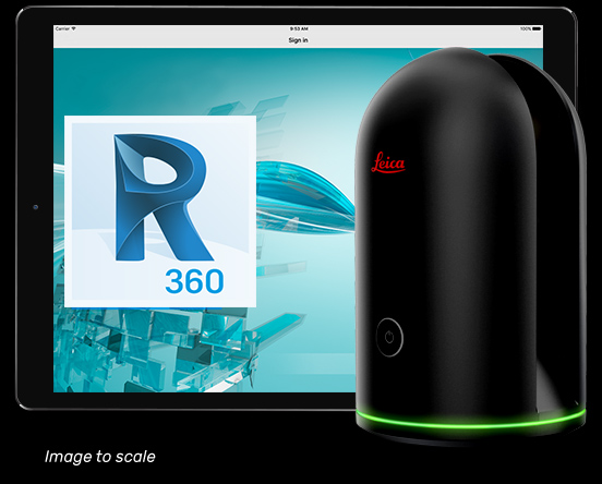
In the 6 months since October’s Intergeo, we have seen announcements of new laser scanners by Z+F and Teledyne Optech, as well as Trimble’s announcement of the fantastically productive SX10 scanner/total station combo. At Autodesk University, Leica Geosystems debuted the game-changing BLK360 paired with Autodesk’s ReCap. In January, we saw a further iteration of the FARO Focus platform with the launch of the lower-cost Focus M70. Just last week, a vendor widely known for its innovations in 360-degree camera technology, NCTech, announced the LASiris VR.
It does not require a crystal ball to predict that these systems will have a strong presence at SPAR3D in Houston next month.
A race to the bottom?
In the case of the Leica, FARO, and NCTech offerings, the prices are making headlines, since the barrier to entry for collecting high-quality 3D data is lowering. Hardware vendors are lowering their prices to the point that a professional 3D capture system can now easily be purchased for between $13,000-$20,000.
Are we at a point where scanning technologies are so competitive that vendors are racing produce the cheapest scanner possible? Is a low-cost scanner the only system that the market will buy?
Let us not overlook new varieties of fruit
In our efforts to understand developments in our industry, it is natural to try and impose categories–even though it is in the interests of vendors to market to the widest possible range of applications as possible.
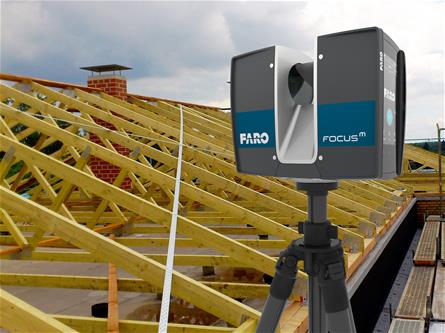 FARO, for instance, is marketing their new Focus M70 as a system designed for professional, industrial scanning. This is no surprise, since it is built on a platform that is already trusted by many scanning and surveying professionals worldwide.
Leica has been somewhat coy about where the BLK360 sits. Undoubtedly, the astonishing engineering and product design effort has led to a new and original hardware platform. Its user experience—including a perceived single-button operation, and use of the Autodesk ReCap platform for control and automatic methods of scan registration—are now opening the market up to users outside of the traditional surveying or laser scanning user. Nevertheless, the surveying market is core to Leica’s business, and the company’s messaging is still focused on the more traditional survey-based uses of the BLK360. This is all good, provided the data meets expectations.
This kind of focus on traditional survey-based work means the professional scanning community risks missing the new opportunities and new markets that are now available to us.
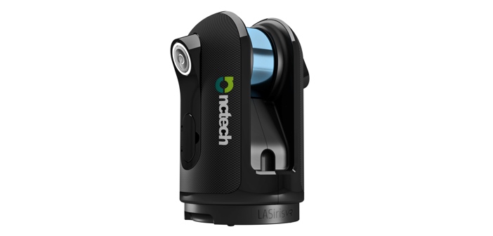
The launch of the LASiris VR offers an alternative approach. (The health warning here is that, as many know, one of my continuous consulting engagements is with NCTech. Of course, I knew about the LASiris VR, but cannot say that I played a part in it.)
Since the unit’s announcement, forum-goers have predictably criticized its resolution as compared to similar scanners on the market. NCTech appears not to mind—the company has marketed the new system as a “3D Reality Capture Camera,” and went so far as to announced it at the Google Cloud Next ’17 conference rather than an industry event. For the LASiris VR, the real technical strides are not in the sensor technology, but in its ability to process data onboard the system itself, or on the cloud. Reducing CPU time in this way will surely bring us closer to really democratizing reality capture.
I applaud my colleagues at NCTech for their foresight in deciding to follow-up on their immersive imagery technologies and create a device for an existing market segment that we tend to overlook.
Real requirements for reality capture
While there is a valid obsession in the professional 3D community with acquiring the most accurate 3D data for less, we often overlook the 3D-imaging applications that do not need survey-grade accuracy. We also overlook the benefits of factors like speed, openness and ease of use. These do not necessarily come from the scanner only, and sometimes result from data processing environment that it is used in.
Let’s take BIM, construction, or facilities management. In these applications, there are still many instances where we need accuracy and precision measurements. Bad data can cost you many times more than even the more expensive scanners available, so there really are applications where you need to invest in the best quality equipment available.
But what if you are a facilities manager who is simply trying to understand what you have in your facility? Or what if you’re one of the large general contractors working on an industrial or institutional build, and you’re obligated to document progress at every stage of a construction project? What you need is fast and clear imaging that is easy to interpret.
I am pleased to see the NCTech team is focusing on these real-world uses of reality capture, and producing a tool optimized for these uses.


