If you want to see a truly epic collection of potholes, come on up here and visit rural Maine, where I spent the last 10 days or so. Between the frost heaves, constant snow plowing in the winter, and generally non-existent town budgets, you can find potholes to swim in. How a place like Hawaii has a pothole “problem” I have no idea. But I’m happy to report that 3D data is helping to solve it.
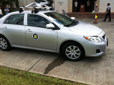
Or so reports KITV-TV, a Hawaiian television station that caught wind of Sam O. Hirota’s gig providing 3D photogrammetric data to Honolulu and the rest of the island of Oahu using earthmine’s system. Okay, so the fact that the city has paid out $20k in vehicle damage claims over the past three years may not exactly scream, “We must solve this problem, now!,” it does seem like pavement maintenance is a real need for any municipality and that the earthmine solution is likely to save time and money:
The current road survey process takes two years where data is handwritten and requires four crew members. This new high tech version takes less than a month.
I’m not entirely sure why the crew members couldn’t enter the data into a spreadsheet on a laptop, or even the notes section on their phones, but if they are, indeed, writing the information down on pieces of paper, I’m guessing the data provided by earthmine’s solution is worlds better than their current process.
This sort of asset counting and evaluation application is right up earthmine’s alley. I sat in on earthmine’s user meeting at SPAR International and they presented a number of use cases along these lines. The most impressive involved the city of San Diego, which used the earthmine system to count its light poles. Apparently, the city pays a portion of its light bill as a multiple of the number of light poles it owns – the problem was, it didn’t actually know exactly how many light poles were in the city. After counting them using the earthmine solution, the city found it had guessed badly and had been paying for 10 percent more light poles than it actually operated.
How’s that for ROI?
No, the data isn’t engineering grade, and there’s an estimated plus/minus of about 4 cm on any measurement you’re taking, and if you’re doing something like trying to figure out how much clearance you have on a given street you’d like to navigate with a tall truck or crane, pulling up the earthmine data will allow you to do that in pretty quick fashion.
Further, even if the accuracy isn’t engineering grade, it’s at least relatively uniform, which is more than can be said for a crew worker eyeballing road conditions:
Department of Facility Maintenance Director Westley Chun said the snapshots will help officials identify and track road conditions, including potholes. “It won’t just be based on complaints. It won’t be based on subjective observations,” said Chun. “It’s a scientific-based method that we’ll be using.”
When might it be necessary to use mobile laser scanning instead of this photogrammetric-based solution? How might they complement one another? Will this image-based solution continue to get more and more accurate?
Well, considering there are only 20 of these systems operating in the world right now, it might be too early to answer those questions definitively, but I think the technology should definitely get some wheels turning (sorry, couldn’t help the pun – still getting back from a fun-filled vacation, after all…).


