

We’ve written previously about lidar’s use in the wind-energy sector, as it’s been fairly extensively used to determine where to place wind turbines and a general area’s potential for creating power via wind energy.
Now comes news the U.S. Department of Energy will be goosing researchers’ ability to study how best to use lidar to determine wind-farm feasibility. By all accounts, the Chesapeake Light Tower, a former Coast Guard lighthouse about 13 miles off the coast of Virginia Beach, will be converted into a the Reference Facility for Offshore Renewable Energy (read: not oil), which will be organized by Pacific Northwest National Laboratory, with renovation help from National Renewable Energy Laboratory. The facility should be operational by 2015.
Germane to this space is that they’ll be testing lidar devices quite a bit. To wit:
With these instruments, researchers measure wind strength and direction by emitting light and then observing when and how some of that light is reflected off of tiny bits of dust, sea spray or other particles blowing in the breeze. Lidar devices for offshore wind measurement would be placed on buoys in the ocean. However, ocean waves move buoys up and down, which would also send the device’s light beams in multiple directions. So scientists have developed methods to account for a buoy’s frequently changing position to collect the wind data they need.
That’s where the reference facility comes in. Mathematically corrected data from buoy-based lidar is a new ballgame for the wind energy industry. To prove that the data they collect are both reliable and accurate, wind assessment lidar devices would be placed both on buoys floating near the facility and also on the facility itself. Wind data would be collected from both sources and evaluated to determine the buoy-based technology’s accuracy.
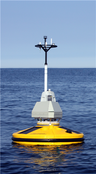
It wouldn’t surprise me if they were using the wind-lidar buoys developed by Fugro, as announced this past summer. The Fugro buoy was quite the advancement, with R&D minds from Norwegian universities, Statoil, and Fugro Oceanor all chipping in together to figure the technology out. As you can see in the accompanying picture, it’s a fairly compact device, which should be relatively easy to deploy and maintain, though it may be a bit difficult to see in bad weather conditions.
And the results they got in testing are pretty amazing:
Validation of the Wind Lidar Buoy took place at an exposed location off the coast of Norway. The tests were designed to compare wind data collected by the buoy to data from a similar lidar located on land and from a fixed met tower. Wind velocities up to 20 m/s and wave heights up to 5 metres were recorded. The average deviation in wind speed measurements between the Wind Lidar Buoy and the reference stations was less than 2 percent.
One wonders how else that research might be applicable. Could similar software allow for better mobile scanning operations? Maybe even hurricane and tornado warning systems? It will be interesting to see what comes of the research done at the new facility.


