

These are the kinds of guys we need to be giving a bigger and better platform. In the lead of his column regaling the happenings in the Kenai National Wildlife Refuge printed in the Peninsula Clarion, which covers the Kenai Peninsula of Alaska, Mark Laker declares that acquiring the the Kenai Peninsula 2008 lidar data “was better than Christmas.” Depending on your religious/consumer leanings, that’s pretty dang good.
A GIS analyst/ecologist, Laker was enthused to have 500 gigs of data dumped in his lap, not only because of the possibilities for his own work, but also because it gave him the chance to play Santa Claus himself, distributing the data further to engineers and geologists and whomever else showed an interest. When people are this geeked up to work with your technology, you must be doing something right.
Pretty quickly, Laker provides an overview of what he likes about the data:
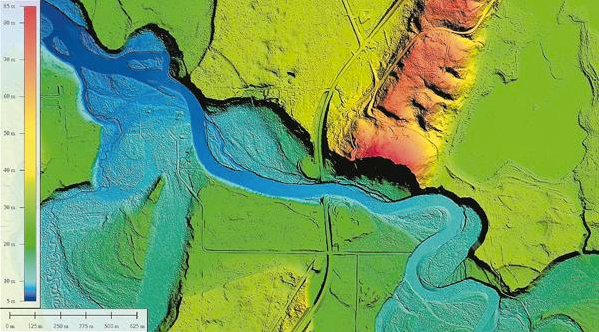
The area surveyed included the Western Kenai Peninsula and the upper Kenai River Watershed. The lidar data are used to produce a Digital Elevation Model (DEM) and a Digital Surface Model (DSM). A DEM represents a bare (bald) earth model of the land, as if all the trees and structures were removed. From the DEM, a variety of products can be produced relatively easily such as elevation contours (down to 2 feet), flood plain and tidal surge maps, and wildfire risk assessments. A DSM on the other hand includes all the trees and structures and is useful for aerial navigation, forestry, viewsheds, radio propagation, etc.
(I’m not 100 percent sure about using data as a plural noun, but I’m going to overlook it for the moment.)
Just as quickly, we learn of Lake’s pain points:
These products require some heavy computing power to produce, but are relatively straight forward. The raw LiDAR data itself holds a wealth of information; the hard part is filtering out the parts you want.
Plus the fact that, you know, it took three years between collection and distribution because the data needed so much processing before it would have value to someone like Laker.
Really, there are two clear tasks here for the 3D data capture community: 1. How do we get this data from collection to usability faster (and along they way make it easier on the processors)? 2. How do we give people like Laker a platform so that more entities see similar value in the data and are more likely to requisition it and pay for it?
Maybe the answers to both questions are the same. Is there a quick and dirty way that, say, an iPad app could be created that works with lidar data to create only very specific deliverables? Could that same technology for the iPad app be reskinned to have a consumer allure? Maybe it’s a 3D fly-through of a national park for consumers that doubles as a way to plan and outline aerial navigation? Is there a forestry management game like Sim City that could double as an honest-to-goodness forestry management tool?
Hey, I’m no software developer, but when guys are talking about things being better than Christmas, there’s clearly an opportunity there.


