In the wake of the devastating flooding that swept across central and southern Texas this summer, images of submerged roads, stranded families, and overwhelmed emergency crews have dominated the news. With climate change intensifying the frequency and scale of these events, communities are turning to high-tech tools to not only map the risk—but to save lives when waters rise.
Technologies like lidar, drones, and real-time 3D mapping are rapidly reshaping how we prepare for, respond to, and recover from natural disasters. These tools—many of which have been regularly highlighted by Geo Week News and Commercial UAV News—are becoming central to emergency management strategies across flood-prone regions.
DEMs and lidar provide foundational knowledge
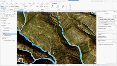
Before the storms hit, getting accurate digital elevation models (DEMs) with lidar are crucial in identifying flood-prone areas. Using high-resolution elevation data collected from airborne sensors, lidar allows engineers and planners to model how water moves across a landscape. These models are far more accurate than traditional topographic maps, especially in dynamic urban environments or rural areas where subtle changes in terrain can mean the difference between safety and inundation.
Agencies such as the USGS and FEMA rely on lidar for national-scale flood risk assessments. In Texas, local governments and civil engineers have increasingly adopted LiDAR to inform decisions about levees, evacuation routes, and drainage infrastructure. For example, the Texas Water Development Board (TWDB) has a modeling and mapping program that develops and updates flood maps using the latest technology. The program (in partnership with FEMA) helps to create Flood Insurance Rate Maps and provides flood hazard data that should be used for land use, insurance rates, and planning for natural disasters.
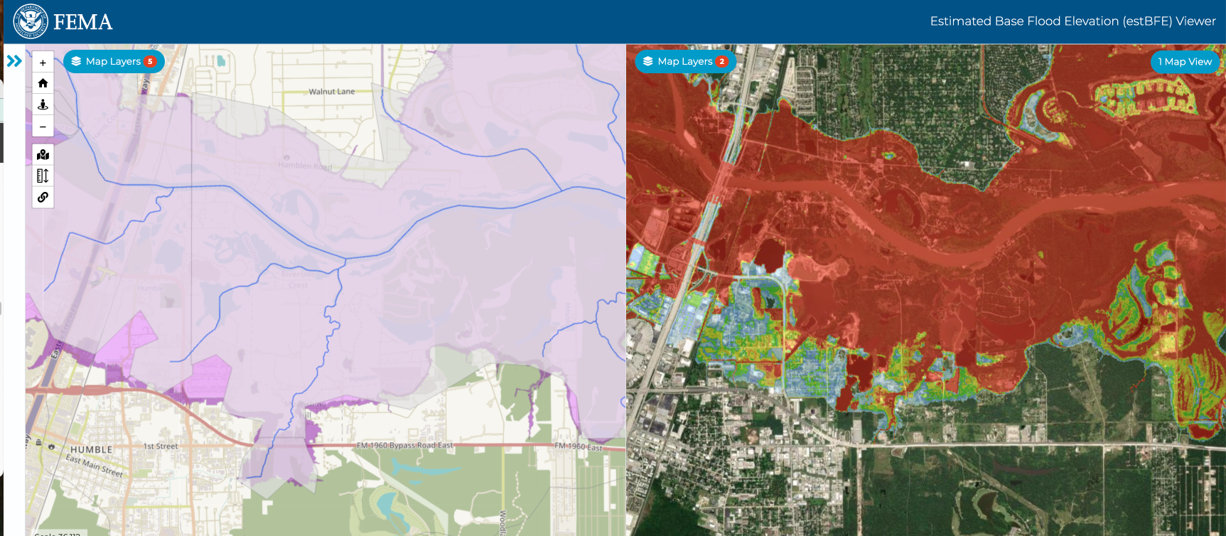
To modernize and expand these efforts, the TWDB is using Base Level Engineering (BLE)—a streamlined, cost-effective mapping approach that combines high-resolution lidar elevation data and advanced modeling techniques. Unlike traditional mapping that targets individual stream reaches, BLE analyzes flood risk across entire watersheds. It produces engineering-based flood hazard data and estimated base flood elevations that communities can use before official regulatory map updates. BLE results are publicly accessible via the Estimated Base Flood Elevation Viewer, allowing local officials, planners, and residents to interact with flood data, assess risks, and guide smarter development and mitigation decisions.
Tools enabling quicker responses
Recent advancements in mobile and drone-mounted lidar have made it easier and faster to collect this data, particularly after storms when on-the-ground access may be limited. Once floodwaters rise, drones are proving to be essential tools for real-time response. Across Texas, emergency crews used drones to assess damage, locate stranded individuals, and even deliver emergency supplies to areas that were inaccessible by land.
As covered by Commercial UAV News, drones can be put to use in disaster response. Sometimes equipped with thermal imaging and cameras, drones from emergency responders are being used to find people trapped on rooftops or in vehicles. Public safety agencies increasingly deploy drone fleets not only for aerial mapping but also for direct integration into rescue operations and providing live video feeds to incident command centers.
In past flood events, such as Hurricane Harvey, Texas first responders deployed drones for damage assessment. Now, those deployments are more sophisticated, faster, and more connected to broader geospatial platforms, thanks to developments in AI and edge processing.
What’s next?
The recent flooding in Texas has underscored a hard truth: as climate-driven disasters grow more frequent and severe, traditional tools and responses aren’t enough. Fortunately, lidar, drones, and digital mapping technologies are no longer emerging solutions—they’re established, effective tools already in use by agencies across the country. With continued investment in programs like BLE and wider adoption of drone-based response strategies, communities can act faster, plan smarter, and ultimately save more lives. The technology is here. The challenge now is making sure it reaches the people and places who need it most—before the next storm hits.