


Contributed by Greg Milner
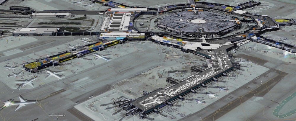
Weary travelers lost in San Francisco International Airport (SFO) can access a map of the facility on their cell phones. The map, built with geographic information system (GIS) technology, provides the information to get them where they need to go. But there’s much more to the map—it guides operations.
These additional layers, accessible to the people who run and maintain the airport, reveal the airport’s dazzling complexity. All 1.8 million square feet of the International Terminal are included. Every individual component—from the 15,000 doors to the 2,000 trees—is present and accounted for.
Peel back those layers and peek underground. You’ll find the 400 miles of labeled subsurface utilities, including water, electrical, and wastewater. The airport’s exteriors are pictured, gathered through lidar and other methods, seamlessly integrated into the GIS.
For operations detail, building information models (BIM) find their place on the map. Closets, walkways, plumbing—it’s all there, ready to aid in repairs or long-term projects. Informative GIS layers, such as the location of wireless access points, augment the detailed BIM information.
And this is just the static map information. Indoor tracking shows the position of critical equipment. Outside, the current locations of maintenance vehicles are revealed.
From the public version to the sensitive high-security layers, it’s all the same GIS-supported map. But it’s more than that. This is SFO in its entirety: the permanent parts, the semi-permanent, and those items are always on the move.
So let’s not call it a map. What SFO has built is a geospatial digital twin.
The Evolution of Digital Twins
The concept of the digital twin is not new, although it has undergone radical alterations. The earliest digital twins appeared in the manufacturing world, as far back as the 1980s. They were a way to measure the performance of factory machinery and processes, down to the level of individual components.
Although helpful for understanding plant operations, the utilities of these early digital twins were limited. An analyst could note strengths and weaknesses in the system, and detect problems and bottlenecks, but would struggle to apprehend its totality.
Modern digital twins provide this totality, without compromising granularity. Just as the human body relies on the interconnection of systems such as the respiratory system and the cardiovascular system, complex systems in organizations function through constantly flowing interactions. A modern digital twin recognizes that interactions among systems are just as important as the individual systems themselves.
The Complex World As It Is
How does a geospatial digital twin create the conditions for this nuanced view?
First, by offering clarity of vision. From the time GIS first debuted over a half-century ago, the technology has pioneered the concept of digital twins.
The visual language of GIS is the map. Just as a paper map is, to varying degrees, “an analog twin,” many GIS-derived maps can be thought of as digital twins. GIS maps contain details about attributes, data can be traced to its source, and they transcend the static maps of the past.
GIS can produce realistic digital twins because the technology can now seamlessly integrate immersive 3D environments, including details obtained via drones and reality capture techniques.
Geospatial digital twins go further than 3D models by adding the dimension of time. Like the systems they mirror, digital twins evolve. By compiling information regarding the past and present, digital twins can be used to query what happened when and even what’s likely to happen based on past patterns. Advanced analytic techniques reveal trends and hotspots.
No Two Twins Alike
As more people have grasped the potential power of geospatial digital twins, use cases have multiplied. It is now possible to speak of many categories of digital twin:
- Design and construction digital twins help manage complex infrastructure problems, while providing a through-line that connects the present with the future. In Brisbane, Australia, a digital twin aids in the construction of a new subway. The same twin also depicts areas above ground, so that the rail authority can track how the underground project impacts economic development above it. When the project is complete, the same twin will guide daily operations.
- Digital twins have become an indispensable tool for architects and urban planners. The technology helps them imagine and experiment with alternative scenarios without any disruptions to the real world. What would a proposed promenade look like, given current walking and pedestrian traffic in the region? How high should a bridge be, based on various climate change flooding scenarios?
- Digital twins of utilities networks provide a detailed physical view of systems that are often concealed from view. In the United Kingdom, the wireless provider Vodafone now uses a digital twin that covers 245,000 square kilometers of its network.
- Environmental digital twins have recently emerged as a way to understand ecosystems and how they function. Perhaps their most valuable attribute is the way they link natural systems with human-made systems, revealing how each affects the other.
The Common Denominators
The most exciting digital twin model to emerge in recent years attempts to combine all of the above into something that mirrors the complexity of entire cities, or even nations. Grenada, for example, has built an impressive country-level digital twin that helps the Caribbean nation understand and prepare for climate change.
The mirroring ability of digital twins can obscure qualities that are more prosaic, but no less powerful, than the ability to mirror dynamic systems.
Digital twins foster collaboration and communication. They provide a common view for stakeholders to understand how systems may evolve. And their visual intuitiveness is a way explain progress to communities, regulatory agencies, or anyone else who may be affected by evolving systems.
Finally, there is the power that has long made GIS an optimal way to organize spatial information.
The many data flows that comprise complex systems may originate from disparate sources. Oftentimes, the only thing these groups of data share is that they have a spatial component, a shared location. GIS-based digital twins honor this similarity while visually emphasizing it.
Geospatial digital twins offer something that approaches complete contextual awareness. By helping us visualize the cross-pollination of data flows, these digital twins connect abstract data with concrete experience. By answering the constantly shifting question of “where?”, geospatial digital twins offer the ultimate contextual understanding.
Learn more about how GIS creates digital twins of the natural and built environments.
This article originally appeared in the Esri Blog.
 Greg Milner is a writer in the strategic content group at Esri, where he tells stories about how location intelligence is transforming our world and how we perceive it. A former magazine editor and political speechwriter, he is the author of the books "Perfecting Sound Forever: An Aural History of Recorded Music" (a finalist for the National Book Critics Circle Award) and "Pinpoint: How GPS Is Changing Technology, Culture, and Our Minds.".

 (1) 1.png.small.400x400.png)

