

A small portion of the Internet is blowing up with an article wittily titled, “Indiana Jones goes geek: Laser-mapping LiDAR revolutionizes archaeology,” posted on the popular tech site Ars Technica. I’ve seen the WSJ link to it and plenty of aggregation sites are cutting and pasting the text to try to steal some real estate on the next big search term (people open second browser: “what is lidar?” Yeah, even though there’s a definition right on the page. Trust me), which is great for the 3D biz.
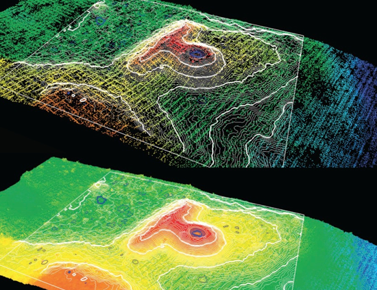
Essentially, the article summarizes the work that was first published by Chris Fisher, Stephen Leisz, and Gary Outlaw in October 2011 in PE&RS about their work through Colorado State at Sacapu Angamuco, in Mexico, an ancient city that was active at the time of the Aztecs, but hasn’t gotten nearly the press. With the improvements in lidar accuracy, firms like Merrick (who did the collection in this case; Outlaw is their VP of Geospatial Solutions) are now able to fly over sites like these that have grown up into forest and jungle, use their MARS software to remove all the vegetation, and supply archaeologists with data from which they can pick out individual dwellings, altars, pyramids, etc.
For us in the biz, who understand the possibilities offered by multi-return lidar data, it’s kind of like, “duh, of course they can do that,” but like any new application of technology, someone out there has to be the first one to give it a go and prove the benefits that it can provide. It’s not like anyone can just fire up a plane, fly to Mexico with an Optech system strapped its belly, and start collecting data. Funding must be acquired, proof of concept must be offered up, some sort of tangible return must be postulated.
Saying you can pick out an old pyramid with airborne lidar is one thing. Saying you can pick out 3,800 individual archaeological features in just eight weeks is quite another, which is what happened when Fisher, Leisz, and Outlaw put their plan into action. They estimate lidar cut fieldwork costs by a factor of four over “traditional” GPS-based, ground-based methods (and don’t even get started on the improvement over measuring tape and the like), meaning they could map in about two years what would have previously taken as much as 10 years.
Seems like that would be pretty handy.
Best of all, the public loves both of these things: ancient civilizations and lasers! The story has been up on Ars for about 30 hours or so, and already the comments are flying in and questions are being asked by the general public. And why does the web rock? Well, because Fisher and other lidar experts are already weighing in with answers! It goes without saying, but never has information been able to travel so quickly.
I love this particular piece of added explanation from Fisher in the comments:
We use program called MARS from Merrick & Co. – the firm that acquired the data for us. It has built-in filtering capabilities. We received the data pre-filtered by Merrick using their own ‘bare earth’ filter. Interesting conceptually is that this removed all the archaeological features – their bare earth is different then mine. We then created a filter based primarily on elevation to restore the archaeological features. It’s imperfect – better tools have been written but they are not available to civilians at this time.
So, the next time someone wonders why everyone’s bothering about the archaeological market (who cares about old stuff?!?), here’s a pretty good reason: These academic researchers are clearly intimately involved in helping Merrick develop and fine tune their product. Just think what other applications might want something different than completely bare earth.
I’d encourage everyone in the lidar field to give the comments a read, really. What started out as an article to introduce this concept to a mainstream audience turned into a pretty thorough case study, actually.
(Oh, and by the way: Why do you think everyone started paying attention to this article in the first place? Yeah, it was that headline. If it had been something like, “Case study: How the use of lidar is helping archaeologists to reduce their fieldwork time by a factor of four,” no one would have read it (or far fewer). Just putting in a little pitch there for why writers matter, while I’m at this…)


