

I hope you were able to make it to The Woodlands for SPAR 2012 last week. I certainly enjoyed meeting many of you in person and thoroughly enjoyed catching up with a lot of old friends. I would cover the conference for you, but that’s been done very well by Sam Pfeifle. I will say that the standout items for me were the sessions on Open 3D & the Point Cloud Library, the MDL mobile solution with the Faro Focus 3D on the nose, and the number of people that gave me a “replacement card” as they had changed companies in the last year.
SPAR is full of people offering solutions to the various problems we in the 3D imaging world find ourselves dealing with every day. It’s encouraging, but there are some issues that seem to always cause problems but never get mentioned at SPAR. One of them has been on my mind quite a bit lately – the responsibility of the field crew.
To listen to those on the exhibit floor, the field crew collects data and that is all. It’s so easy, you rarely see it addressed anymore. I’ve made a fair amount of money over the years helping to save projects by registering data that didn’t seem to fit or modeling from “unregisterable” datasets. Nine out of 10 times, the problem was due to a lack of information from the field crew. As my cousin Michael Billingsley, SIT (TX), reminded me last week, “Field notes are 50% of surveying.” He is absolutely right.
At one time the field notes were almost the entire survey. If I were required to hand record each measurement while navigating and carrying a chain and performing the calculations via trig tables in longhand in a little yellow book that could fit in my pocket I would be in a lot of trouble. Compared to that work, drawing it out was fairly painless. However, asking one of today’s field techs for accurate, legible field notes is worse than asking to date his sister! Today we have convinced ourselves that the data logger, and images or a print out from Google Earth is enough.
With point cloud data it can be even worse.
I don’t agree with this mindset. I think a field agent should be able to drop the data and notes on the desk of someone else and that it should stand on its own from that point. Even if the field notes are not scaled or incredibly accurate, at least I can see what the field tech thought he was doing. How many times have you seen the person registering the data have to call the field collector over and over again for clarification? “Which target numbers did you not use again?” “I’ve got four partial scans. Are these power failures or are they to be included in the data?” “Do you have a target height for target 5008?” “Is the control file in feet or meters?”
It can get quite ridiculous!
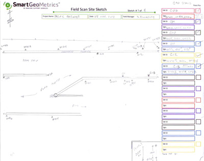
A simple site sketch with scan locations and a listing of each target (along with height above a known point if applicable) can save a lot of phone calls. An important thing to remember is that those phone calls do not just stall registration; they also stop field work. Now you’ve got two projects being slowed down. Bringing everything to a stop because someone couldn’t be bothered to document their work is not only a waste of profit but often it is a sign that sloppy work is being performed. Sometimes field guys get lulled into this through a sense of confidence in the office staff’s ability to figure it out. However, this should be discouraged! Figuring it out may save having to recollect the data, but it always takes more time and money than the project was proposed to require. Those are the types of problems that can sour a good vendor-client relationship in a hurry.


